BY LETTER
Astrography
Science > Astronomy
Galactography
Culture and Society > Technology Levels in Society > High Tech Societies
Galactography > Maps of the Terragen Sphere
Galactography
Culture and Society > Technology Levels in Society > High Tech Societies
Galactography > Maps of the Terragen Sphere
 Image from Kevin Williams (copyright) | |
| Image used with permission | |
Interstellar cartography, determining one's position in space, naming of interplanetary and interstellar bodies and regions, the science of interplanetary and interstellar map-making.
Every interstellar civilization needs at least one way of determining one's position in space, but there are few standards of interstellar cartography or naming that are universally accepted.
Naming is a perennial problem. In the first place, the names of systems, stars, planets and other objects are not universal. The human home system is alternatively called Sol, Terra, Earth, SolSys, Origin, Orb Gaia, Zonnesystem, Home, Temet, Original Sun and many other names - and that is perhaps the most well known system of all. Stars usually have many names in different cultures, and in catalogs they all have different numbers. Some famous stars are well known like Arcturus or Deneb, but most inhabited systems orbit stars which no culture has ever bothered naming and hence get local names from the inhabitants. Planets are often formally named after the star they orbit and which number they are from the star (like Tau Ceti III), but there are odd complications due to elliptic orbits, multiple stars, disagreements on what constitutes a planet or even the addition or removal of planets. In practice, they are named by the inhabitants which lead to many repetitions and possibilities of confusion. At least 40 planets are named TerraNova, and if all planets with a name meaning "New Earth" are counted, they likely number in the thousands - at least. To further confuse things, sometimes systems are named after their most populous or famous planet, sometimes the reverse.
When it comes to naming regions of space, there are many informal ways. A common way is to mention some notable astronomical feature like In the vicinity of Ascella or Corewards of M21. Especially bright stars, well-known worlds, star clusters and major nebulae are used. Directions are often based on global directions of the galactic disc such as: "above/north", "beneath", "corewards", "rimwards", "spinwise" and "counterspinwise", corresponding to being above or below the galactic plane, closer to the core or further away from it and along the direction of rotation or against it. Another system uses the constellations as direction markers, usually assuming the Sun as the origin (but of course, many cultures use their own constellations and their own systems as origin). This is crude and solarocentric, but works well for everyday use. The most common translation between galactic directions and constellations is above - Coma, below - Sculptor, corewards - Sagittarius, rimwards - Gemini or Taurus, spinwards - Cygnus and counterspinwise - Vela.
A common convention is the use of the term 'cluster' to denote a set of linked or nearby systems, even if they are not part of any physical stellar cluster (most star clusters consist of young hot stars of little interest to bioids anyway other than as landmarks and scenery). Due to the uneven spread of colonization there are many volumes where the local density of inhabited worlds are noticeable higher. Clusters can be linked into local wormhole nexuses, or just share a common region and history.
As for determining where one is, there are many popular systems. One of the oldest is galactic coordinates, where locations are determining by galactic latitude, longitude and the distance to the Sun. Unfortunately there are uncertainties or disagreements in the positions of the Sun, the galactic plane and distances which makes these coordinates unreliable in the outer reaches of human space. It is still useful as a rough guide. Local coordinate systems of the same kind are quite popular, as well as rectangular systems calibrated by the position of a central star and two others. Another system lists the angular separations of a number of easily identifiable bright stars such as Eta Carinae, Deneb and Rigel. This is much more accurate but cumbersome for non-cyborgs to comprehend, and mainly used for running starship navigation.A third system divides space into a honeycomb based on a series of nested Voronoi tesselations with centers at each star brighter than a certain magnitude. This denotes volumes of space by naming a series of stars from the brightest to the closest, but is not particularly precise and depends on everybody sharing the same star catalogs.
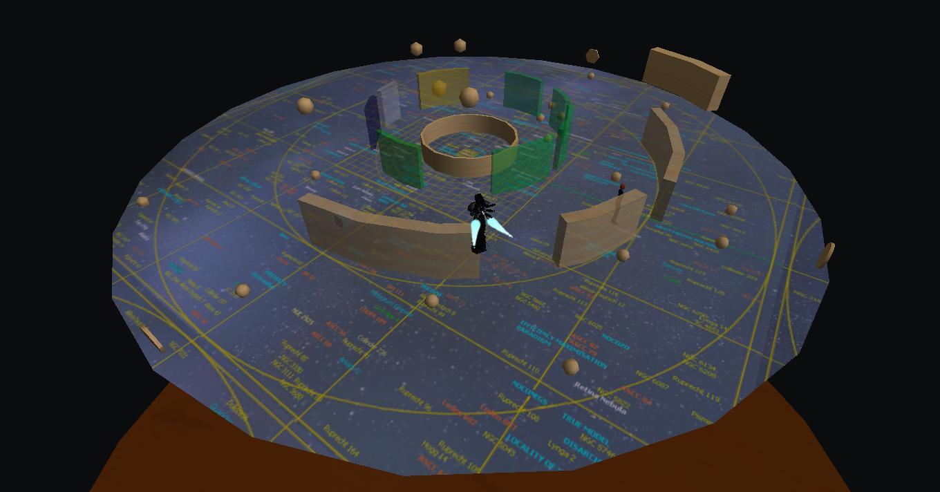 Image from Chris Shaeffer |
Within systems, there is a bewildering multitude of coordinates. Often some form of spherical or rectangular system is used (although phase space coordinates and null-geodesic lattices are popular in some regions), with heliocentric, local or planetary origins and wildly different ideas about measurement scales and calibration directions. Visitors to inhabited systems should always download the Local Coordinate Framework Manifest (ComEmp Ontology), Navigation Local Subontology (Concord Ontology), System Reference Document (First Federation standard) or similar document from the local authorities. Note that in systems with several polities and cultures independent and incompatible coordinates may be used.
Related Articles
- Astrogation, Astronavigation
- Epoch (Astronomy)
- Galactic Directions
- Light-year - Text by M. Alan Kazlev
The distance light travels in one standard or metric (Earth) year, viz. 9.46x10¹² km. Standard unit of measurement. It is equal to 6.323x10⁴ astronomical units (AU) or 0.307 parsecs. - Parsec - Text by M. Alan Kazlev
Unit of distance at which a star would have a parallax of 1 second of arc from a planet of exactly 1 astronomical unit (AU) distance from its primary. One parsec is equal to 3.262 light-years, 2.063x10⁵ AU, or 3.085678 x10¹³ kilometers.
Appears in Topics
Development Notes
Text by Anders Sandberg
Initially published on 03 July 2000.
Initially published on 03 July 2000.